
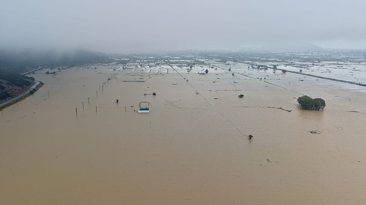
Five consecutive days of intense rain and thunderstorms have left flooded land, destroyed roads and serious damage in rural areas across much of Crete, an island counted among the Mediterranean’s most important tourist destinations.
Measurements by the National Observatory of Athens illustrate the volume of rain that fell, mainly on the island’s mountainous regions. According to the network of automatic weather stations operated by the Observatory/meteo.gr, 91 millimetres of rain had been recorded by 15:10 on Sunday alone at Xyloskalo, in the Chania region of western Crete, at the entrance to the Samaria Gorge, one of the island’s best-known natural attractions.
One millimetre of rain corresponds to one litre of water per square metre. This means that 91 millimetres is equivalent to 91 litres of water for every square metre of surface. The National Observatory reported that high rainfall totals were being recorded, mainly in Crete’s mountains, for a fifth consecutive day.
Even larger amounts of water were measured on the Lasithi Plateau, a fertile upland basin at an altitude of around 840 metres in eastern Crete. According to the head of the Crete Development Organisation, Thodoris Ninos, about 440 millimetres of rain fell in the area in just two days, or roughly 440 litres per square metre.
He added that average rainfall in the area over four days of the severe weather reached around 470 millimetres, in a region where total annual rainfall normally ranges between 700 and 900 millimetres.
The huge inflow of water was also evident at the Aposelemis dam, about 30 kilometres east of the city of Heraklion, which is a key source of drinking water for the Heraklion urban area and parts of eastern Crete. The reservoir’s reserves rose from around 9.26 million cubic metres on 30 September to more than 12.7 million cubic metres on 4 October.
The difference exceeds 3.4 million cubic metres of water in just four days. The Crete Development Organisation estimates that the level may continue to rise, as water from the Lasithi Plateau is still flowing into the reservoir.
Between 1 October and midday on Sunday, the Fire Service received 485 calls across Crete. Crews carried out 96 pump-outs of floodwater and 101 transfers of people to safe locations. An 80-year-old livestock farmer who had gone missing in Karines, in the regional unit of Rethymno, was found dead, and the authorities are investigating the exact circumstances of his death.
The impact was not confined to eastern Crete. Damage was reported in all four of the island’s regional units: Chania in the west, Rethymno in the central-west, Heraklion in the centre and Lasithi in the east. Floods and landslides hit mountain villages, farming and livestock areas, as well as stretches of the coast with heavy tourist activity.
Satellite mapping by Copernicus
Greece has activated the European Union’s Copernicus Emergency Management Service – Mapping, under activation code EMSR933, to produce maps of the affected areas through the analysis of satellite imagery.
The data will be used by the authorities to map the flooded areas, assess the damage and plan recovery operations. The request was submitted by Greece’s civil protection authority and approved by the European Union.
Lasithi: Plateau turned into a lake
The most serious agricultural damage is being reported on the Lasithi Plateau, one of Crete’s key farming areas. Large tracts of land were covered by water and mud, rural roads were damaged and potato and vegetable crops were inundated.
Cretalive, citing local figures, reports that around 3,000 tonnes of potatoes and vegetables may have been destroyed and that roughly 85% of the area’s crops lie within the affected plain. The final losses have yet to be calculated.
On Lasithi’s southern coast, Ierapetra and tourist resorts to the east of the town, such as Ferma, Koutsounari, Agia Fotia and Makry Gialos, were hit by torrents and landslides. Roads were blocked or badly damaged, vehicles were swept away and dozens of people had to be moved from hotels and other accommodation to safe locations.
Rethymno: Rivers overflow and destruction in Mylopotamos
In Rethymno, mountainous Mylopotamos was among the areas that took the heaviest hit. In Zoniana, a river burst its banks and the streets turned into torrents, while mud and debris caused damage to homes, the road network and infrastructure.
Between 30 and 40 residents were evacuated from their homes, according to local reports, while damage to the water supply network left villages without water. On the slopes of Mount Psiloritis there were also significant losses of livestock, with farmers reporting dozens of dead or missing animals.
In the municipality of Amari, damage to the road network and continuing difficulties in getting around led to in-person schooling being suspended on Monday.
Heraklion: Damage from the mountains to the tourist coast
In the regional unit of Heraklion, problems were recorded both inland and along the coast. In the municipality of Malevizi, Cretalive reports extensive damage to the rural road network, boreholes and irrigation systems, particularly in mountain settlements.
The impact was also felt on some of the best-known tourist beaches of northern Crete. Nea Kriti reported large quantities of mud, reeds, wood and other debris washed up on the beaches of Ammoudara and Karteros, while in Hersonissos erosion led to the loss of a significant part of the sandy shore.
Chania: Damage in Platanias and people trapped in Samaria
In western Crete, serious damage was recorded in the municipality of Platanias. In Apopigadi and Palaia Roumata, sections of rural roads became impassable, while the mayor of Platanias told the Athens-Macedonian News Agency of damage to roads, water networks, chestnut orchards and livestock facilities. The municipality plans to request that a state of emergency be declared in the area.
A special operation is also under way in the Samaria Gorge. By Sunday evening, eight employees of the National Park remained stranded in a safe spot after the hiking trail turned into a raging torrent. They were in good health, had food, medicines and means of communication, and had been instructed not to attempt to move until the water level dropped.
Government delegation in the affected areas
On Monday an expanded government delegation is travelling to Crete to assess the damage and coordinate recovery efforts. A meeting is scheduled at the Region of Crete headquarters, followed by site inspections in Mylopotamos, Ierapetra and the Lasithi Plateau.
The delegation includes the ministers for Infrastructure and Transport and for Climate Crisis and Civil Protection, along with government officials responsible for agricultural production and natural disaster recovery.
The recording of damage is still under way, particularly in the farming sector and on the road network. In many areas the full picture is expected to emerge only once the waters recede and access has been restored.